

Below are some longer distance routes in the local area
South Downs Way

About the Trail
- Start: Winchester, Hampshire
- End: Eastbourne, East Sussex
- Length: 100 miles (160 km)
The 100 miles (160 Km) long South Downs Way National Trail follows the old routes and droveways along the chalk escarpment and ridges of the South Downs. The route provides the visitor with the opportunity “to get away from it all” without having to travel too far in this busy part of England. The undulating route provides a wonderful trip for long distance bike riders as well as walkers. It also provides interesting day trips and short breaks.
Most people take 8 or 9 days to walk the whole 100 miles (160km) at 12 – 15 miles (25km) a day.
It’s worth considering if you are walking that the villages where you can find accommodation are at the foot of the hill, so you’ll have to walk down in the evening and up in the morning.
Download a guide leaflet here
- - - - - - - - - - - - - - - - - - - - - - - - - - - - - - - - - - - - - - - - - - - - - - - - - - - - - - - - - - - - - - - - - - - - - - - - - - - - - -
Sussex Border Path


The Sussex Border Path is a 150 mile (240 km) long footpath, roughly along the inland boundary of the county of Sussex. It links Thorney Island in the west to Rye in the east, and one of the wonderful things about it is, that if you’re a keen Sussex walker, you’re likely to find yourself crossing it or walking a stretch of it in multiple parts of the county. It was first devised and published in 1983 by Ben Perkins and Aeneas Mackintosh. The county of Sussex owes its origins to the kingdom of the South Saxons.
- - - - - - - - - - - - - - - - - - - - - - - - - - - - - - - - - - - - - - - - - - - - - - - - - - - - - - - - - - - - - - - - - - - - - - - - - - - - - -
Monarchs Way
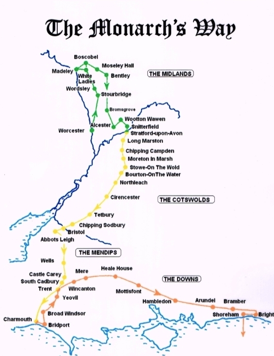
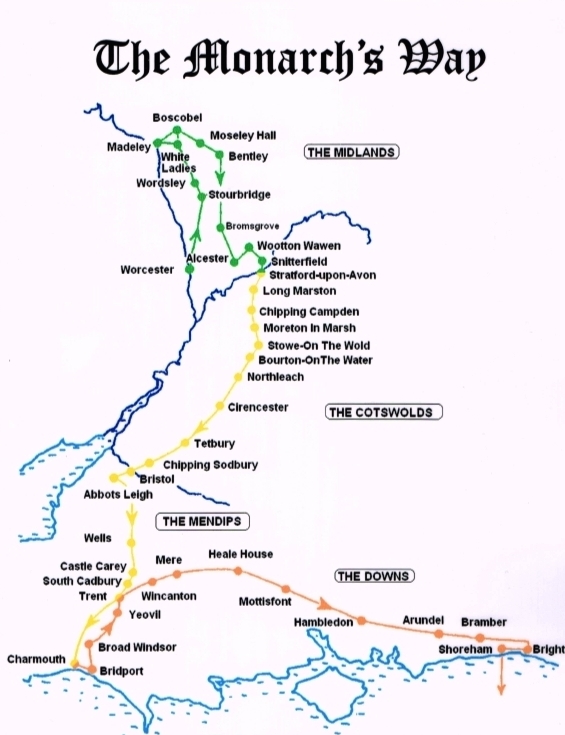

Monarch’s Way is a 625 mile (1,006 km) long-distance footpath that roughly follows the escape route taken by King Charles II in 1651 after being defeated in the Battle of Worcester. It runs from Worcester to Shoreham in West Sussex. It’s waymarked all along the way including the large section that wiggles and winds its way around Sussex. The waymark is a drawing of the ship Surprise above a crown and the route takes in some stunning Sussex countryside and views. The route was established in 1994 and is one of the longest English long-distance footpaths.
There are a series of 3 guide books that split out the walk into Worcestershire & Midlands, The Cotswolds, Mendips and the Sea and The South Coast, the Downs and Escape! Each book costs £10 or you can purchase all 3 for £25.50 which includes postage and packaging. See the Monarch’s Way website for details on how to order a guidebook.
If you are just planning to walk the Sussex section of the Monarch’s Way, it enters the county along with the Sussex Border Path at Stansted Park in Stoughton. From here it passes through West Dean and over Trundle Hill offering panoramic views of Goodwood Racecourse. The route then heads through the pretty villages of Charlton and East Dean before heading to Houghton. After passing through Houghton, the route heads south through Arundel Park towards Arundel, before heading east towards Findon. From Findon, the route continues east to Bramber and then south to finish at Shoreham-by-Sea.
- - - - - - - - - - - - - - - - - - - - - - - - - - - - - - - - - - - - - - - - - - - - - - - - - - - - - - - - - - - - - - - - - - - - - - - - - - - - - -
1066 Country Walk

About the Trail
- Start: Pevensey Castle, East Sussex
- End: Rye, East Sussex
- Length: 31 miles (50 km)
The 1066 Country Walk is a 31-mile, relatively easy, low-level route through countryside that witnessed the Norman Conquest. Starting at Pevensey Castle (and heading north towards the Pevensey levels), it passes Herstmonceux Castle, the historic 1066 Battle Abbey and Battlefield, medieval Winchelsea, ending in historic Rye.
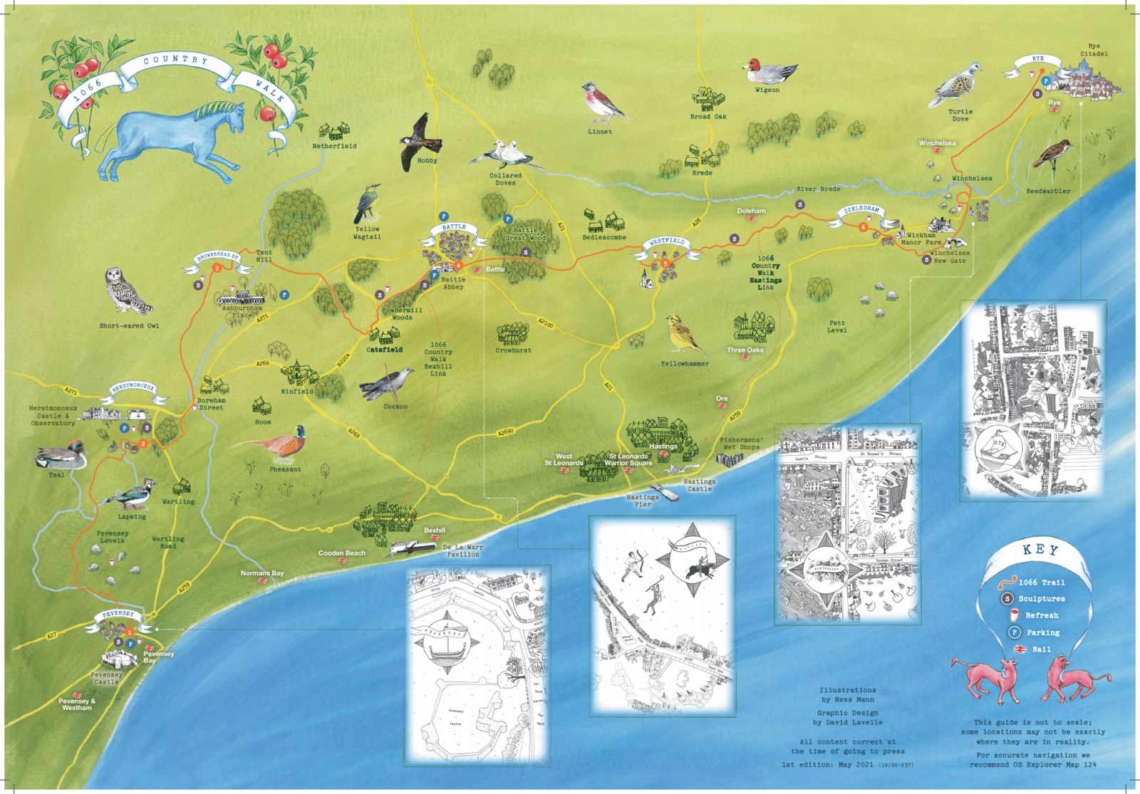
Much of the walk passes through the High Weald Area of Outstanding Natural Beauty, a typical medieval landscape with rolling hills and valleys, atmospheric marshes, ancient woodland, historic towns, quaint villages, old churches, rustic farms, elegant estates, oast houses and windmills, and plenty of cosy pubs and cafés along the way.
Pevensey Start/End point: Pevensey Castle, Castle Road, Westham, Pevensey, BN24 5LE. Starting from the sculpture within the castle, take a left out of the castle gates and cross the road. A minute down Castle Road you will see a small pathway on your right. Look out for the 1066 Country Walk discs here. This heads off towards the Pevensey Levels. Please note that very soon you will need to cross the busy A27 Pevensey Bypass so dogs must be kept on leads and we advise childrens hands are held on this approach.
Rye Start/End point: West Undercliff, off Udimore Road, Rye, TN31 7DX (near Gibbet Marsh car park). The start of the footpath is at the junction where Udimore Road meets West Undercliff. Lookout for the 1066 Country Walk discs and the Southern Water gate.